The National Hurricane Center has slightly increased the chances of a tropical disturbance furthering development in the southwestern Caribbean Sea over the next seven days.
A tropical depression could develop over the weekend or early next week as the system drifts into the central or western Caribbean, where conditions will likely be conducive for further strengthening.
Tropical Storm Patty will be the next named storm, should the system continue developing once wind shear shifts and the storm gets into warmer waters.
“Next week, most of the wind shear will shift to the north of the Caribbean, and so it will create a pocket with high ocean temperatures, plenty of moisture, and very low wind shear that will be favorable for tropical development,” said AccuWeather Lead Hurricane Expert Alex DaSilva.
AccuWeather places the odds of the storm’s development at 90% and warns that there will be rough surf and downpours across the Caribbean next week, regardless of development.
Potential Tropical Storm Patty development is hindered by high wind shear, but that will change next week
The southwestern Caribbean system has been slow to organize over the past week, which AccuWeather says is a result of high wind shear in the area.
“High wind shear is why development has been slow to evolve. It has created a very hostile environment for showers and thunderstorms to organize into a tropical threat. There is not a lot of dry air in place, so it’s just the wind shear that has been holding things back,” DaSilva explained.
Most of that wind shear will shift by next week, according to DaSilva, leaving a “pocket” of high ocean temperatures, high moisture, and low wind shear, which would otherwise hamper the system’s ability to organize.
AccuWeather revises its tropical scenarios

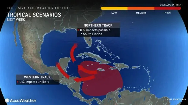
AccuWeather has revised its two tropical scenarios from Wednesday, saying that the western track is now unlikely to impact the U.S. The northern track could still impact South Florida. AccuWeather no longer indicates a potential threat to the rest of Florida and the Carolinas.
“Storms in the Caribbean usually move to the north or northeast in November. This means that residents and visitors from Florida (including the Gulf Coast) to the Carolinas will have to keep a close eye on development,” cautioned AccuWeather Lead Hurricane Expert Alex DaSilva. “Even if a tropical storm forms and tracks into Mexico or Central America, changing steering winds can turn that storm to the northeast and toward Florida later on.”
The system will be slow to develop, but strengthening could be fast
As we’ve already seen, the system could take a bit of time to ramp up and become organized. This is pretty typical behavior for storms that come out of the CAG, but the slow development shouldn’t lure anyone into a false sense of security.
High wind shear in the area has curbed recent organization and overall development from the system, but that’s expected to change this weekend and early next week.
Once development occurs, storms can quickly ramp up. AccuWeather points to Hurricane Oscar as an example, which rapidly intensified from a tropical storm to a hurricane in just a few hours.
Potential Tropical Storm Patty timeline
There isn’t an accurate timeline for when a potential storm could have any impact on the U.S. just yet. As of now, the best estimates are that the system could develop into a tropical depression or tropical storm this weekend or early next week.
Once development happens, meteorologists will be quick to provide information regarding the storm’s path and timeline.
The National Hurricane Center is tracking two tropical waves in the Atlantic basin
There are two tropical waves in the Atlantic basin.
The first wave is along 53/54W, south of 15N, moving westward at 15 knots. There are scattered showers and embedded thunderstorms near the northern end of the wave axis.
The second tropical wave is over the central Caribbean. Its axis is along 73W, south of 17N. It’s moving westward at 15 to 20 knows. The wave is enhancing convection over western Venezuela and northern Colombia.
What else is happening in the Gulf of Mexico?
There’s a high-pressure system near Bermuda causing strong winds and choppy seas across most of the Gulf of Mexico. Thunderstorms are present in the northern part of the Gulf. The windy weather is expected to continue through the weekend, especially in the southern eastern Gulf and around Florida.
The post Tropical system in the Atlantic has 90% chance of cyclonic development first appeared on The Yucatan Times.


