There has been a bit of a lull in the Atlantic hurricane season since Hurricane Oscar hit parts of Cuba last month, with remnants then soaking parts of Atlantic Canada.
But the tranquility is now over as the U.S. National Hurricane Center is looking at three disturbances in the Atlantic at the moment, one of which came roaring to life as Subtropical Storm Patty on Saturday morning. It is the 16th named storm of the current Atlantic hurricane season.
Patty, situated in the North Atlantic, is currently centered more than 480 kilometers west-northwest of the Azores. It has current wind speeds of 85 km/h and is moving east-northeast at 11 km/h.
A faster, east-southeastward motion is expected through tonight, followed by a turn toward the east and east-northeast on Sunday and Monday. Little intensity change is expected today, but gradual weakening is forecast through early next week. Patty could degenerate into a post-tropical cyclone by late Sunday.
Patty is expected to produce rainfall amounts of 25-50 mm across the Azores through Sunday.
Swells generated by Patty will affect the Azores over the next couple of days. These swells are likely to cause life-threatening surf and rip current conditions.

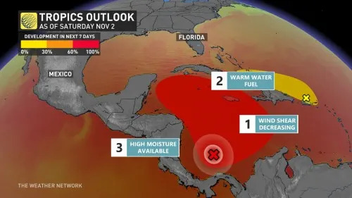
The second of those disturbances, located in the southwestern Caribbean Sea, has an 80 percent chance of developing into a tropical depression within the next seven days. A tropical depression is likely to form by early next week while the system moves generally northward to northwestward over the central and western Caribbean Sea.
Regardless of development, locally heavy rains are possible over portions of the adjacent land areas of the western Caribbean during the next few days, including Jamaica, Hispaniola, and Cuba.
If the storm does get named, as the chances indicate, it will become Rafael, the 17th named storm of 2024.

Impacts to the U.S. are unknown at this time, but the storm could move northwards next week, bringing heavy rain, gusty winds, and rough surf.
Meanwhile, there is a third system stationed near the Greater Antilles, but its chances of tropical enhancement are low over the next seven days (10 percent). A trough of low pressure extending from near Puerto Rico eastward over the adjacent waters of the Atlantic is producing a large area of showers and thunderstorms near and over portions of the Greater Antilles and the Leeward Islands.
Slow development is possible during the next couple of days while the system moves west-northwestward near the Greater Antilles. Then, this system is expected to be absorbed into the low-pressure area over the Caribbean Sea. Regardless of development, locally heavy rains are possible during the next few days from the northern Leeward Islands westward across Puerto Rico and Hispaniola to eastern Cuba and the southeastern Bahamas.

This serves as a good reminder that the Atlantic hurricane season officially runs until Nov. 30, so it’s important to remain vigilant and prepared throughout this month, as well.
TYT Newsroom
The post Hurricane Season 2024 is still active in the Atlantic first appeared on The Yucatan Times.


